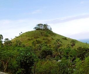
Bukit Mencol is only about 186 m high, but the walk to the top takes just 15 minutes, and from the summit you see Bali's eastern sea and, on clear mornings, the outline of Mount Rinjani on Lombok. The hill is in Banjar Dinas Gili Selang, Seraya Timur village, about 14 km from central Amed along the Amed-Seraya coastal road.
When to climb and how long it takes
- Best time: sunrise, around 6:00 am local time (WITA). The hill faces east, so sunsets are far less dramatic.
- From Amed: 25-35 minutes by scooter. Leave at 5:15 am if you are staying in Jemeluk or Lipah.
- The climb: about 15 minutes, short but steep and completely exposed. The grassy slope is slippery after rain.
- At the top: a small temple under a kepel tree. Dress modestly, do not climb the shrine structures and do not sit in the shrine area.
Fees, parking, facilities
The Seraya Timur village website says the hill is not yet managed and has no proper facilities, so according to the village and VisitBali there is no entry ticket (checked September 2026). Park on the roadside near the houses and give a small parking tip if someone is watching the bikes. Toilets are only available by asking at residents' stalls, so ask politely and buy a drink. The last 300 m or so of road is broken asphalt, which is easier by scooter than by car. Camping is possible on the flatter part, but ask residents first and take your rubbish with you.
Before you go
- Location: View on Google Maps
- Recent photos: search on Instagram. The hill changes colour with the season: green in the wet season, dry brown at the peak of the dry season.
- Combine with: Gili Selang, Bali's easternmost point, in the same hamlet.
Not great for small children, bad knees or anyone who struggles in the heat: once the sun is up, this treeless slope heats up fast. If you want a more serious hike in the same area, Mount Seraya takes about two hours. For Mencol, be back down before 7:30 am and have breakfast in Amed.



Kommentare 0
Noch keine Kommentare. Schreiben Sie den ersten!